

“DANGER KEEP OUT”
Back in March, I reported on the mysterious case of additional cameras and pole mounts appearing at Rattlechain lagoon, which had actually been erected last year and also a query put to Sandwell council about this and if any planning permission was required.
It subsequently transpired from the reply from SMBC that planning permission WOULD be required for additional cameras to the application originally submitted in 2010 of the single pole based camera covering the front entrance and supposedly the whole pool.

“permission would be required for any additional pole mounted cctv on the site”
The planning application in 2010 was reference DC/10/51860 (Proposed construction of a 10m high column equipped with a CCTV camera).
This ONLY gave permission for one camera, at the main entrance, with no night vision and requirement that local residents in neighbouring houses were screened from any Trinity Street peeping Toms,(or circumstances to that effect).

Since this march post, and if you will excuse the pun, there have been some developments on these particular unauthorised erections.
I did indeed complete the attached enforcement form and this was then left in the council’s hands for action. Unfortunately it appeared to me for some time that those hands weren’t exactly taking any and had gone rather limp in response. Chasing this I then received the following confirmation from the SMBC planner in May.

“In the first instance I have reviewed the regulations for permitted development rights in relation to CCTV equipment and the camera does require permission as was the case in 2010, Solvay have been made aware of this and I have chased for an application to be submitted as soon as possible. Clearly we will review in more detail its location and where the camera is directed to ensure that the privacy of residents is not compromised. On speaking with Solvay, they stated that the camera was erected due to the break-ins on site and concerns about the risk to individuals.“
Having not had any confirmation of any application I followed this up again receiving the following.

“I apologise for not responding, I did contact Rhodia/Solvay back in May and they confirmed that they would submit an application. However as you state sometime has elapsed and still no application. Therefore I have now written a formal letter stating that the lighting columns require permission and if an application is not submitted by the end of August, then enforcement proceedings will be instigated.”
One can see from this how Rhodia operate. They avoided not only making an application but also depriving the much “cash strapped” Sandwell council of a planning fee for the application. 😳
But let’s be clear here, their oversight, subsequent ignorance and now the retrospective planning application itself are all designed to try to disguise the contents of their still “hazardous waste area” site and the still current waste management licence governing the established use of this former clay pit.

THE RETROSPECTIVE APPLICATION.
Three documents were submitted with the application which has been given reference number DC/17/60912 .
First to note about this application is the invalid plan of the current site. For some reason Rhodia or their agents have used the plan of the site as it stood in 1975, BEFORE the stopping up of the right of way RP97 in John’s Lane! The Albright and Wilson site was reduced in size as a result of this land sale to the reckless dumpers of Duport Properties Limited.

Are they just stupid, and are they that unaware of this area that they have submitted a wrong plan, or is there something more cunning afoot here? SEE BELOW
DC_17_60912-PROPOSED_LAYOUT_PLAN-908949
Their current site boundary is of course the one below, which they actually submitted in the 2010 application, and which identifies the area as having 5.76 hectares– note this important figure for later on.
DC_10_51860-PLAN_OF_RATTLECHAIN_MERE__A3_-406754
It could be argued that they are trying to project to anyone who doesn’t know the site- ie Sandwell council planners , that the cctv posts are well away from the current public footpath and so are well contained within the site. We also get the return of the ludicrous “rattlechain mere”– this is the deception that was being used by the likes of Tom Dutton and works managers in the early 2000’s when they were trying to claim that their hazardous waste landfill tip and its contents was not responsible for birds being poisoned there.
Of note in the drawings and positions of the pole cameras are
“4m HIGH POSTS 2 FIXED CAMERAS PER POST 1 POST C/W SPEAKER CAMERAS – 720TVL PICADIS VARI-FOCAL IR BULLET TYPE CONTROLLED BY 24hr SURVEILLANCE BY ROBOWATCH”
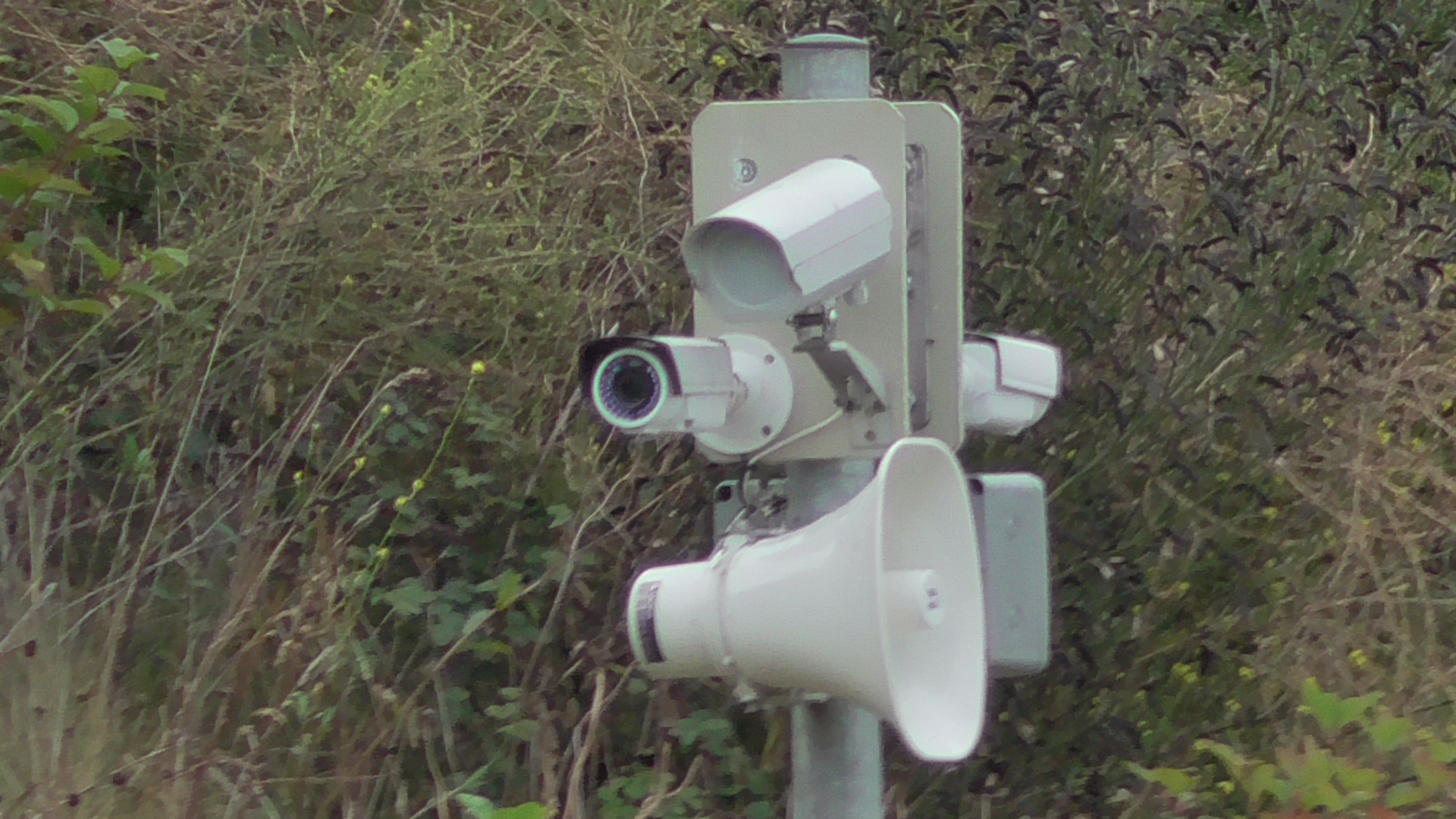
“Good morning campers, Hi di Hi!”
“EXISTING 10m HIGH POST AS PER PLANNING PERMISSION 2010 DC/10/51860 3 ADDITIONAL FIXED NON PIVOTAL CAMERAS IR ZOOM LENSES TO PROTECT PRIVACY OF NEARBY RESIDENTS SCREENS HAVE BEEN ELECTRONICALLY BLANKED OUT.”

I’m not sure that this is English, yet it appears to be suggesting that the cameras have been “electronically blanked out”. WELL WHAT DOES THAT MEAN EXACTLY? IS ANYONE ABLE TO REMOVE SUCH SAFEGUARDS AT SOME POINT AND HOW?- IN THE INTERESTS OF PROTECTING NEARBY RESIDENTS PRIVACY?
The application form itself can be read below.
DC_17_60912-APPLICATION_FOR_PLANNING_PERMISSION-908934
There are numerous questions and statements made in here some of which are just not true or accurate, just like the invalid plan submitted of the site.

We get confirmation of what we already know concerning the two erections on the North embankment which are 80 metres apart and that this work commenced on 27th July 2016 being completed on 8th November 2016.
The most interesting thing about this is not the reason why there was considered a need for these extra cameras, but the complete lack of mention of the site’s dangerous contents which are of course the real reason for their erection.
“Following on from civil’s works at Rattlechain it was found that persistent intruders were entered the site by cutting through the North boundary fence followed by digging into the North bank slopes in the search for collectable bottles.
The excavations into the banks were quite severe with concerns that intruders could have caused death/ serious injury to themselves or for the newly formed banks to have slipped causing extensive damage.”
Firstly the supposition that anyone has entered the site digging for bottles is just that- where is the evidence?
I noted these diggings some time back, actually believing that Rhodia or their contractors had made them, especially given that they coincided with the area of the former gulley where the old discharge pipe that was used to tip waste from the Matty canal boats was located. One would expect this area to have been more heavily contaminated on this embankment, and so may well be tested to determine the extent of white phosphorus/phosphine being present in the soil/embankment after it had been covered.
It seems highly unlikely if you read ERM’s appraisal of the embankment works that any slippage would occur from such diggings, so we are left with the final statement which is of note. Undoubtedly Rhodia are fully aware that intruders could cause “death/serious injury to themselves”, not as a result of falling from what is a fairly typical embankment in this area, but as a consequence of the nature of material present in the embankment and still contained within the lagoon itself.
Perhaps if they were clear and were not desperately trying to conceal this, then one could have more sympathy for this application, but as it is this is just another in a long line to which I have become an expert in unravelling the Trinity Street liars real motives.

The site address is given as the ludicrous “rattlechain mere.” I thought this had been dropped some time around a decade ago, but obviously they are trying to create images of disassociation away from the rattlechain tip/lagoon toxic association. Of course they attempt to do so in vain.
“description
“open area of natural habitat surrounding a small lake at the end of John’s Lane.” 😆
ABSOLUTELY BLOODY LAUGHABLE NONSENSE! I DON’T THINK EVEN BARRATT HOMES DESCRIBED IT IN SUCH ELOQUENCE WHEN PEOPLE WERE PARTING WITH THEIR MONEY ON THE FORMER SEWAGE WORKS SITE AND THEN FOUND OUT THE TRUTH AS TO WHAT THEY HAD REALLY MOVED NEXT TO.

THE REAL DESCRIPTION- AS DISPLAYED BY RHODIA LIMITED IN SEVERAL PLACES AROUND THE SITE PERIMETER.

Confirmation of the camera specifications and also the invalid plan of the site that they submitted with it.

Rhodia claim that “the site is no longer used”. This in terms of them depositing any further toxic waste may be true, but it remains “in use” in that the licence governing the site has not been surrendered. It has not been surrendered because Rhodia would have to demonstrate that the site poses no future risk to anyone in the area. THEY HAVE NOT DONE THIS.
IT STILL IS AND DOES CONTAIN HAZARDOUS WASTE CHEMICALS!
How is it possible that Rhodia can lie about the site not being land which is known to be contaminated?
How is it possible that Rhodia can lie about contamination being suspected for all or part of the site?
THE WHOLE SITE IS…….
Just for clarity , here is what was stated in the 2010 application.

“isolated” and “the nature of the waste materials” YES It sensible to install a camera but it not sensible to have dumped the waste there in the first place.

OF COURSE THIS QUESTION IS ALSO QUITE IRONIC, GIVEN THE LOCATION.

The declaration confirms that Rhodia knowingly have submitted false and misleading information with this application.
It is quite bizarre that the cheeky buggers have in the camera details even lifted pictures off this website to demonstrate what the cameras and posts look like during their construction! These of course were used to demonstrate how they had failed to submit an application to start with!
DC_17_60912-CAMERA_DETAILS-910490
Well two can play at that game. Here are some direct quotes from their propaganda website, set up after this one to try to counter some of the truths about what was really buried at their site, and what still remains there.

“Please note that the Rattlechain Lagoon is a hazardous waste landfill site with an open body of water. For your own safety and that of others we urge you not to try to gain unauthorised access to the site at any time. The site is surrounded by a metal fence, monitored by CCTV and regularly inspected by a security contractor in order that we can ensure the site remains safe and secure. In an emergency, or if you see any suspicious behaviour, please contact 0121 541 3314 or the Police.”
So just to recap, Rhodia on their own website tell us exactly what the site really is and that it is ALREADY

“Please note that the Rattlechain Lagoon is a hazardous waste landfill site with an open body of water. For your own safety and that of others we urge you not to try to gain unauthorised access to the site at any time. The site is surrounded by a metal fence, monitored by CCTV….”
One must also ask the question if they were concerned about trespass from the North embankment, then why the additional cameras needed at the south of the site, right next to people’s homes?
“The future
“The lagoon will remain a hazardous waste site, will remain closed to any further waste and will still be covered by an Environmental Permit. The Permit has however been varied so as to acknowledge that no new waste is being introduced to the site. This Permit will remain in place and will be enforced by the Environment Agency for the foreseeable future.”


YOU CAN COMMENT ON THIS APPLICATION BY USING SANDWELL COUNCIL’S PLANNING PORTAL. DC/17/60912.