
Historic British Waterways tips on the Birmingham Canal Network
Background
British Waterways’ responsibility for dredging of silt from the canals around Birmingham would have resulted in thousands of tons of silt for disposal. Due to the nature of the “dirty industries” in the area, it is possible (maybe even likely) that some of this silt might have been contaminated. So we are interested in finding out what records might have been created and still exist about these operations.
We asked a number of questions to try and find out more :-
1. We asked : Does British Waterways have a map of the location of its tip sites, both current and previously owned between Oldbury and Coseley?
They replied : “British Waterways does not have a map of tip sites on the Oldbury and Coseley. Our GIS system indicates only one record of a tip in that area at Rattlechain but it is a point rather than a mapped extent of a tip. There was also a general practise to deposit dredgings on the towpath and down embankments where British Waterways owned the land. There were also sites at Rushall Junction (Tame Valley), Moxley tip (Walsall Canal) near Bliston (sic) and the Blue Button tip on the Bradley arm.”
2. We asked : Could you confirm that Alfred Matty of Coseley undertook dredging and disposal works for British Waterways along the network?
They replied : “Alfred Matty did undertake dredging and disposal work for British Waterways. There were many canal based contractors who carried industrial waste such as Alfred Matty, Caggy Stephens, and T and S Element etc, who carried local waste products from the chemical and Iron founding industries by boat to private tips.”
3. We asked : How often would dredging works have been carried out between Oldbury and Coseley on the Old and New mainlines and Gower and Netherton branches, prior to 1988 and the introduction of new legislation towards dredging operations?
They replied : “The dredging would have been done depending on result of surveys showing navigable depth. A significant amount of miles of the Birmingham Canal Network was dredged in the 1980`s using funding from the West Midlands County Council. The Waterways trust’s waterways archive may have more information.”
4. We asked : Where would the most likely deposit of these materials have taken place, for example, a specific British Waterways owned site?
They replied : “The Deposit is more than likely would have been the canal bank, local bank staff can recall the Blue Button Tip was used to deposit some of the dredging material.”

- Blue button tip
5. We asked : Could you confirm which part of the Rattlechain Tip site that you
owned, periods of ownership and when and to whom British Waterways sold
this land?
They replied : “Please see attached historic plans, showing the Rattlechain area and British Waterway’s previous ownership and lease to S Barnett in March 1896.”
View the map showing SHEET 25 RATTLECHAIN AREA HERE
View the map showing SHEET 24 the continuation of the mainline canal and the area of the Albright & Wilson historic tip/Stour Valley brickworks HERE
Our Comment : The maps provided were of great interest and form part of jigsaw concerning the historic route taken by Alfred Matty contractors for disposing of waste at Rattlechain lagoon from Trinity Street.
6. We asked : 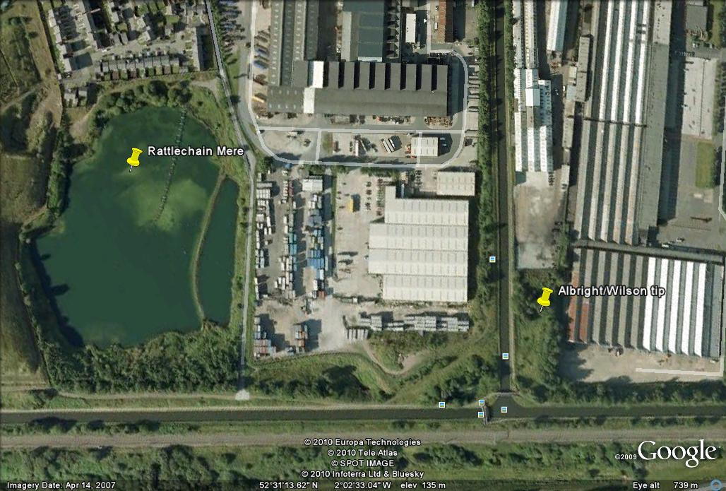 Is British Waterways in ownership of a piece of land at the foot of the Netherton Branch canal which bisects the towpath and the Vaughn trading estate? This derelict fenced off site was a historic Albright and Wilson tip, sold by the company in 1917 to The Vono Company. Tipping ceased in 1919.
They replied : “Please see attached, Map of British Waterways land ownership in the Vaughan estate area. The green lines shows the boundaries of BW’s owned Land.”
Two maps were supplied. View MAP 1 HERE
MAP 2 has a striking view of Rattlechain lagoon! View it HERE
We comment : These images provide striking detail of the Rattlechain lagoon when waste was still being tipped in 1999, the year when we first noted birds being poisoned here. The phosphorescent glow is unmistakable. The map shows that British Waterways are not in ownership of the land we questioned, but are according to the lines, owners of all land beyond the Rhodia fenceline adjacent to the canal.
7. We asked : Has British Waterways undertaken any tests in the area to ensure no leacheate from this site has entered the Netherton Branch and hence the New mainline?
They replied : “British Waterways has not undertaken any tests on this land. If issue was a matter of pollution from adjacent land affecting the canal it would be a pollution offence and therefore dealt with by the Environment Agency. The EA have pollution incidents available on their public register.”
We comment : Unfortunately it appears that everything connected to potential contamination is left to the Environment Agency, though it is unlikely that they would undertake any testing on land contaminated from so many years ago.
WHAT DOES THIS MEAN?
This request reveals that British Waterways claim to have few records or recollection of the historic arrangements to dump the canal dredgings.