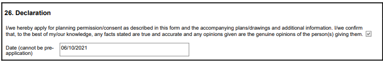
Rhodia , except “Solvay Solutions UK Ltd are the applicants.
It appears that Solvay/Rhodia or whoever the entity in charge of this site like that at Rattlechain is intent on covering up the legacy of one of the worst environmental contaminators to ever come out of the UK- namely Albright and Wilson.
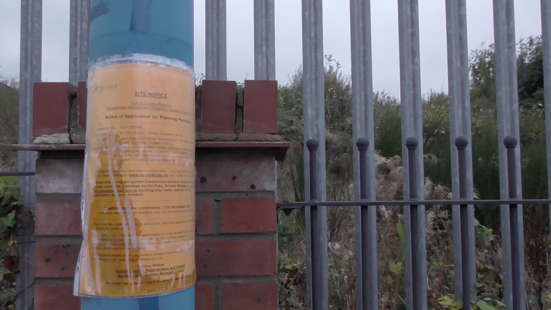
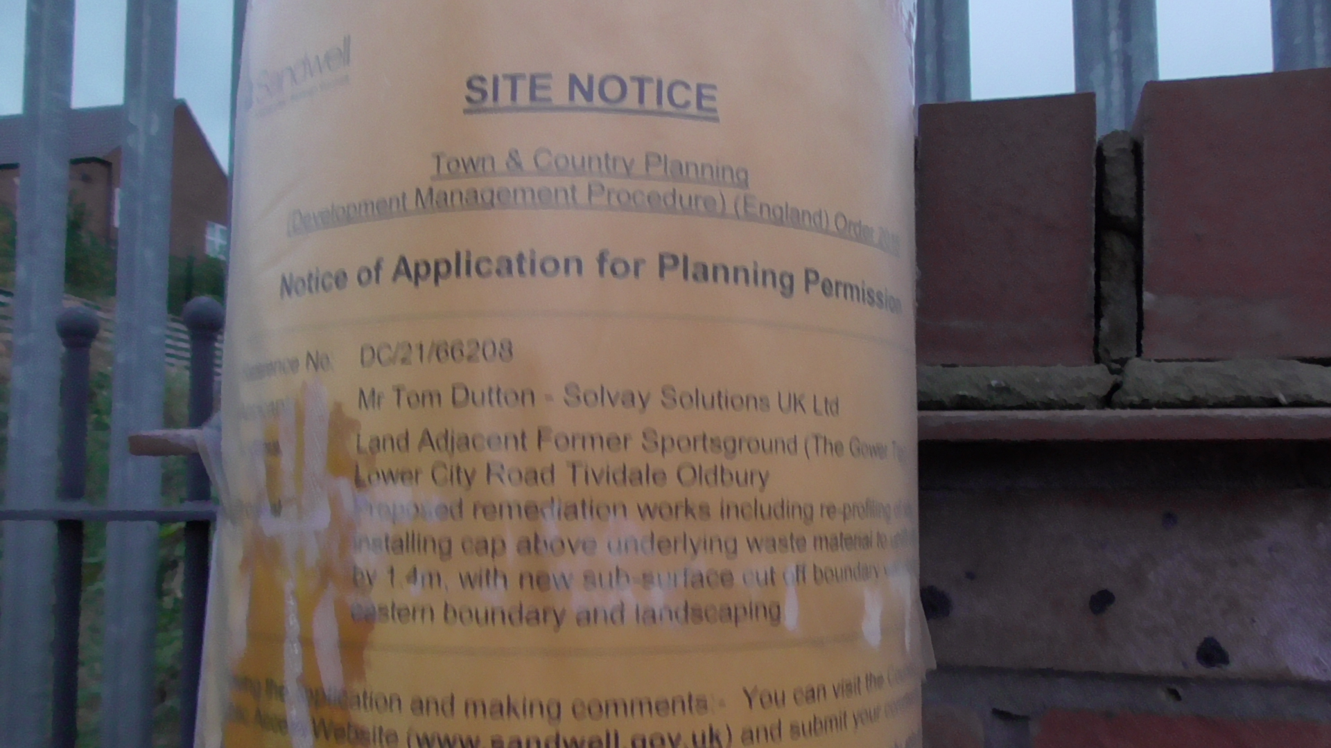
I had exposed the pre spin show bigging up an expected planning application, which for some unknown reason has arrived a month late. Several documents have now been uploaded to the SMBC planning portal, with site notices also posted under the following application.
DC/21/66208 | Proposed remediation works including re-profiling of site, installing cap above underlying waste material to uplift site by 1.4m, with new sub-surface cut off boundary wall along eastern boundary and landscaping. | Land Adjacent Former Sportsground (The Gower Tip) Lower City Road Tividale Oldbury
I will look at each of these in turn, including several reports which largely rehash the same claims , with some of them punctuated by false information and deliberate historic omissions, (particularly of certain chemicals deposited within the site), by Rhodia’s long standing “environmental consultants” ERM, who were behind the 2013 cover up works at Rattlechain.
It should be pointed out that this company was set up in 2004 by a former Environment Agency employee (land policy manager) involved in creating EA policy on remediation and other matters, which comes in rather handy when said regulator has consistently failed to monitor, sanction or improve mothballed historic waste sites like this since the mid 1990’s and then a private sector entity is paid handsomely for the privilege of “remediating” them many years later.
The thing about all of these people is their fetish for the acronym and what lies behind these. I would again point out that if this site is currently “safe” to local residents, particularly those living in the Summerton Road Development orchestrated by Morris Homes a few years ago, then why is there any need for “remediation” of a site that has been in this company’s ownership since the licence surrender nearly 30 years ago?


Firstly the application itself, from which we get few clues, and also a sectional drawing..
DC_21_66208-FULL_APPLICATION_FOR_PLANNING_PERMISSION-1156453
DC_21_66208-PROPOSED_SECTION_DRAWING-1158558
It should be noted in whose name this application is made, one Tom Dutton, sometimes “Dr” but not a medical one, a director of the phantom “Rhodia Limited” and health and safety manager during the days of Albright and Wilson themselves, and also in a high profile position when Rhodia were found guilty in court of the off site emission of phosphine gas from their Trinity Street plant. Rhodia of course attempted to lie about this fact with ludicrous semantics. I have a collection of his business cards to demonstrate his long term involvement with these linked companies, crucially when they were still actively depositing waste in The Gower Tip, a timeline that is falsified in the supporting documents for this application as I will prove with direct evidence. He is well aware of what went in there in the 1990’s at least.
Dutton as a health and safety “professional” openly told gross mistruths at meetings held at Trinity Street about the waste at Rattlechain lagoon, failed to tell me about risks within the site despite being invited into there, (so much for the Health and Safety at Work Act), and of course about the chemical which was later found to be systemically poisoning birds within a site that his company span as being “a safe haven for wildlife”.
He was also caught out when he inadvertently sent me a draft pre-prepared spin letter from Rhodia’s PR officer which attempted to claim that amounts of white phosphorus found within a dead goose found at Rattlechain were “small” , which was hastily rewritten after the APHA concluded that the goose HAD been poisoned by the amount of P4 found.
He also attempted to claim that there were “small amounts” of white phosphorus in the lake, a nonsense he had no doubt repeated by learning from his predecessor , the liar “Dr” Peter Bloore. This phrase was rubbished by actual amounts of weight that were held in site waste returns by the Environment Agency themselves, which I uncovered after putting in an FOI.
In other words, in my opinion from bitter personal experience, you cannot openly trust anything that this man claims about history, current status or chemical nature of wastes within any site owned by Rhodia/Solvay and those formerly operated by the company that gave him a job in the chemical industry- Albright and Wilson .
Perhaps that’s where the paid “environmental consultants” like ERM come in, who also create deliberate omissions within their reports to better aid their clients objectives. They are of course informed by their paymasters, and can state this in any form of litigation that might arise in the future to relieve themselves, not that the EA bother to check, because , well, that’s their policy not to bother. 😉 Albright and Wilson did this with the Cremer and Warner report, with Bloore grossly lying to this independent consultancy acting on behalf of The Black Country Development Corporation with Rattlechain, at the same time as waste tipping at The Gower Tip was also ceasing. I would state that these two events were linked when their polluting collars were starting to be felt.
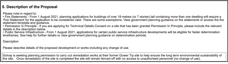
 There is still no explanation as to why this work is necessary at this time, and after so long since the licence surrender in 1994! “Environmental sustainability” is one of those meaningless buzz phrases which means precisely nothing. For 27 years, why was it thought fine to leave it “unsustainable” by the same company, and the same man making the application? Why is the site not environmentally sustainable in the current condition? How is it going to be sustainable when the aim is to keep it fenced off as private land and a still former waste tip with hazardous contaminated chemicals buried there?
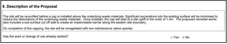
They want to disturb the materials to put in a cap. Why do they need to do this and put residents under undue risk for little gain when the result will be a fence keeping them out? The cap is the crap way in which they and other companies deal with sites such as this. A cheap form of “remediation”, it ensures that they never have to deal with removing the waste off site- a risk created due to houses being built which never should have been without first proceeding with a remediation which never happened under Albright and Wilson and Rhodia- under Dutton’s direct involvement.
The proposal to put nearly 1.5 metres of soil on top of that buried is a give away that they are concerned about what is beneath the soil and the risk it poses. “The impermeable barrier” is a curious one given the fact that they have stated that the tip was a former clay pit, which they have stated previously at rattlechain makes it “impermeable” anyway as a result of the marl. They are clearly aware that there is a risk to residents on this estate from this tip, but like as at rattlechain with the birds, do not want to elaborate.

The end use will be exactly the same as the current use making a nonsense of the “environmental sustainability” claim.
On the issue of the history of the site, this is where the first lie is told. The waste did not cease to be tipped in or around 1986, as they are well aware.
The Environment Agency have published a table of waste sites, which although very poor and erased of detail, do refute this bullshit directly.
Processed-historic-landfill-sites-1 (1)
They have also published guidance on how to interpret the acronyms and language used in the tables.
Historic-Landfill-Sites-Quarterly-Summary-Briefing (1)
Let’s look then at the information that the regulator has published in the public domain concerning The Gower Tip.
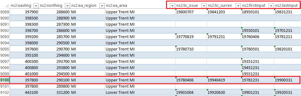
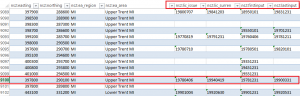
If you go down the list to number 9100 you will find The Gower Tip listed.

If you scroll across still following site 9100 you will find this.

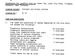
This lists the site licence number (SL32) of which will be prominently referred to in this post, and was also renumbered 644/99 as shown and also LF0054.
Scroll right a little further, and you will find the following under The Gower Tip site 9100 info.
 The vertical columns are defined in the EA guidance as

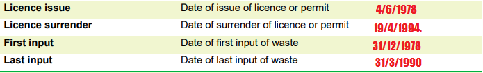
We can therefore see from this that the claim made by Dutton/ERM in this application is inaccurate about the dates of licence surrender, and also of the last claimed input of waste onto the site- by some four years!
This data indicates that the licence was granted on 4/6/1978, as confirmed in the site licence issued by West Midlands County Council which I have looked at HERE. The first input of waste into the site, under this licence was 31/12/1978 according to the info here. The last input of waste is shown as 31/3/1990. The licence surrender is shown as surrendered on 19/4/1994.
The definitive timeline table therefore is as follows.

Sandwell council also supplied me with the following data sheet for the site from Their contaminated land team in an EIR request about the site that they call LF0054.
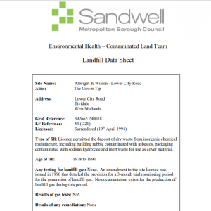
The rather strange “landfill gas” monitoring statement here appears to suggest that no monitoring whatsoever was done at this site, or if it was, the authority which should have demanded it, even passing an amendment to the site licence do not hold any record of such. Whoever was in charge of SMBC and their landfill sites at this time has serious questions to answer as to why they allowed the licence to be surrendered- when they claim here that “details of remediation- none” is shown. I wonder if the council have been reminded of their total negligence with this site under the Environment Act concerning part 2 A, and this is just a latter day attempt to absolve themselves?
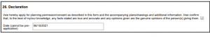
We can therefore see that SMBC appear to hold more accurate information than the useless environmental consultancy and health and safety director of the company concerned, which I find impossible to believe quite frankly. I do hope that the contaminated land team correct the misinformation supplied in the application, which I will be reminding them of, as well as the signed declaration of which they have supplied inaccurate information and facts concerning this site.
REPORTS.
There are no less than 9 reports written by ERM, many of them containing the same misinformation as highlighted above about site history and waste contents dumped. It is also worth noting that they have all been altered according to the preface on each after “client comments”. We therefore see that Rhodia/Solvay/Dutton have editorial control of what ERM report.
DC_21_66208-NON_TECHNICAL_SUMMARY_REPORT-1156467
Apparently, ERM are “in the business of sustainability”, as well as writing bullshit for industrial polluters.
From the start, the claim that waste tipping ceased in 1986 has been seen to be a lie, as was their claimed date of licence surrender, which occurred a year earlier. If they or their clients cannot even get this publicly available information correct, then why should anyone believe anything else in their reports?
The infilling of the site by BIP is new to me, but during the war and after it anything could have gone into here without record, which makes moving around anything on this site extremely dangerous. A further 40 years of tipping before a waste management licence came along is also troubling. ERM omit concerns about this “contentious site” as revealed in minutes of the WMCC pollution control meeting where the licence was discussed.
Four stages are proposed
1.Remodelling the site surface- this has already started with the bogus clearance of material away from houses in George Wood Avenue which I called out at the time when planning permission had not even been granted.
2. Yet another “cap” to hide the wastes and the disturbance of them
3 Addition of groundwater barrier nearest the houses
4 Tree planting.
The claim that significant excavations will be limited so as not to disturb the underlying waste materials is curious, as it appears to suggest that the authors know that they are harmful- why else would they be minimised? This then poses the question as to “if it ain’t broke, then why “fix it”- as a non-technical summary may describe. No real reason s given as to why this bogus operation is required, other than the company at the time of licence surrender had not appeared to conduct any remediation at all.
It appears that their actions will generate surface water on the site- and therefore a possibility of off site wastes leaving the site.
Local residents can expect these operations to take 9 months with the heavy lifting work of capping 6 months! There will be up to 30 HGV’s depositing material every day which will add extra traffic to an already extremely busy road structure. It does not say from where these vans will operate from, or from where the materials will come from or how they are to be screened.
- The first acronym is that of “CEMP” (see below) which roughly translates as B.O.L.L.O.C.K.S.
- The claims about air quality and risk to residents are utter lies. This was the situation at rattlechain during the remediation works there, and there were several complaints about this at the time from local residents who bordered the site.

- They omit any mention of asbestos being buried in the waste materials. They appear to suggest that odours will be released, and to implement mitigation.
- Badgers setts have been identified at the site. It claims that they have “previously been discouraged” from using the site- so what exactly are they saying here- interference with these setts?
- Noise impacts are expected close to the houses during the day- great if you are a night worker I’m sure.
- One of the biggest concerns that I have about these works are the proposed run off of surface water into the River Tame, which is the same culvert via The Brades brook (a Severn Trent Water asset) from which a serious oil pollution affected wildlife in 2020 at Sheepwash Nature Reserve. We have recently seen magenta coloured water entering the Tame from this source, and reported it accordingly. The source has not as yet been identified, and we do not need any other more “invisible” chemical arisings entering from this Severn Trent owned asset.
- They claim that studies concerning the nature of the wastes have been looked at since 1992, yet none of these appear to be in the public domain or included or even referenced in the ERM reports- why, what did they find, who were the authors, and what are they hiding from omission of information as reported at these times? How for example has the waste risk changed?
- Their claims about no risk to offsite receptors is rather fanciful based on their omission of facts about the waste contaminants.
- The montage of images of the view of the site do not appear to show much difference at all, and once again this raises questions as to what Solvay are really trying to achieve with this exercise?
DC_21_66208-CONSTRUCTION_ENVIRONMENTAL_MANAGEMENT_PLAN-1156460
This is the PR piece “CEMP” and is full of theoretical waffling shite- not least the statement from Solvay. The “Solvay way” does not appear to be very different to me to “The Rhodia Way”, and before that The Albright and Wilson way, which was to dump toxic shit into the environment and then deny responsibility for poisoning, human ill health and environmental damage- so long as you can get away with it.
“Solvay monitors that efficient HSE management systems are implemented at every industrial site”– yeah sure.
When they have lied in the application about the chemicals in the site that were dumped there, there is little more to be said.
DC_21_66208-LANDSCAPE___VISUAL_APPRAISAL-1156479
This report looks at the surrounding landscapes and the claimed visual impact of these works. Quite a few pictures of views from different angles, but as such there is little value in this report.
DC_21_66208-LAND_QUALITY_ASSESSMENT-1156489
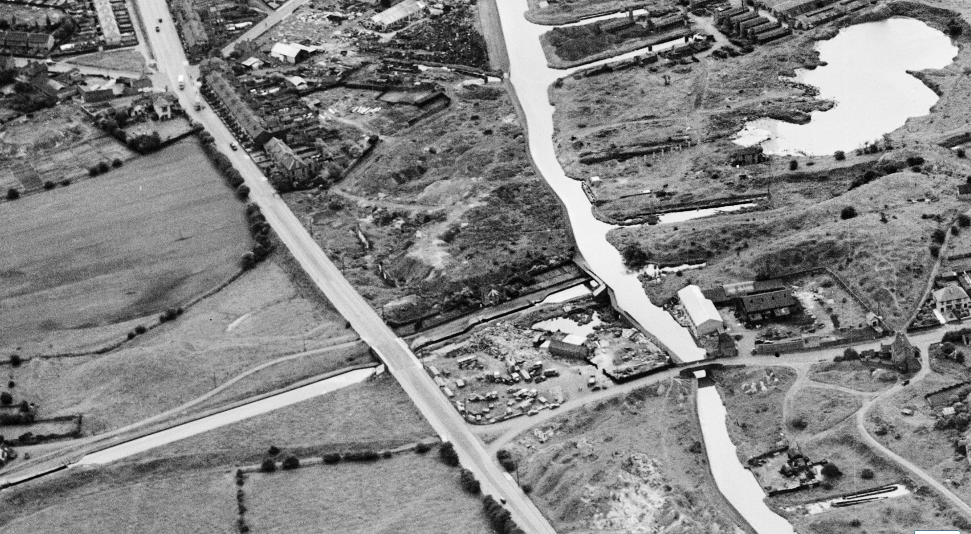
A much rehashed set of information as contained in the other reports, with the same misinformation about historic accuracy. The historic picture shown in the report is very unclear, but the one below demonstrates that the marl pit, like rattlechain was significantly flooded- as shown in the top right of the picture- i.e The Birmingham Old Mainline and the Brades locks from where Alfred Matty boats delivered waste to this and also Rattlechain. The canal basins into the old brickworks site are also shown.

1946
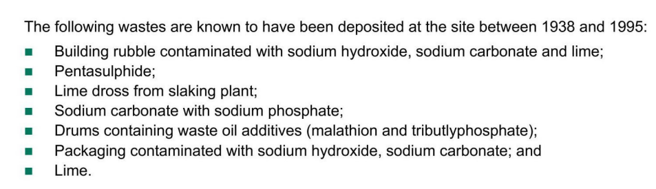
At 3.2 we also get the obscene lie about what types of waste were deposited at the site, from 1978 of course, Albright and Wilson were required to set limits and keep records.
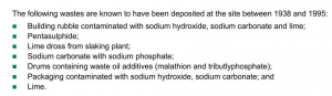
Compare this with the actual licence and the amounts allowed to be deposited during the life of the licence SL32 – i.e between 1978 and 1990
- They omit phosphorus sesquisulphide-
- They omit waste contaminated with asbestos
- The statement of drums of malathion and tribultyl phosphate were never allowed under this licence, and I am not quite certain as to whether this plant had in fact shut down before this licence came into existence? This formed part of the notorious “Oldbury Smell”, a sulphurous stench which stank of Tom cat piss- so will this odour once again be released onto an unsuspecting public? Malathion is also a notorious organophosphate insecticide used in wildlife crime and is carcinogenic. It is also notable that it corrodes metal- which suggests that these long buried drums will have leaked significant quantities of material into the soil itself.
- Tributyl phosphate was manufactured at Trinity Street under the name “Albrite TBPO4“ and is a metal extractant. It is used for the refining of uranium from yellow cake and is used for solvent extraction of a variety of other metals from aqueous streams. It is also found in brake and hydraulic fluid.
The original licence discussion actually states that the risks of phosphorus pentasulphide ( a chemical weapons precursor) and sesquisulphide at this site were the main reasons as to why it was contentious- BECAUSE THEY REACT BADLY WITH WATER. ERM/SOLVAY omit this ley information, and so do so because it suits them to downplay the potential risks associated with these substances being exposed to moisture.
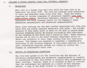
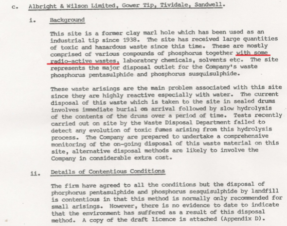
From minutes of The West Midlands County Council Waste disposal and pollution control committee December 1977
“I Background
This site is a former clay marl hole which has been used as an industrial tip since 1938. The site has received large quantities of toxic and hazardous waste since this time. These are mostly comprised of various compounds of phosphorus together with some radio-active wastes, laboratory chemicals, solvents etc. The site represents the major disposal outlet for the Company’s waste phosphorus pentasulphide and phosphorus susquisulphide (sic).
These waste arisings are the main problem associated with this site since they are highly reactive especially with water. “
The pentasulphide reaction with water produces the toxic gas Hydrogen sulphide as well as phosphoric acid.
P4S10 + 16 H2O → 4 H3PO4 + 10 H2S
- They also of course omit any mention of the “radioactive wastes” mentioned in this report or any up to date information about what these were or if they remain on site. I asked questions of both the EA and Sandwell council about this, with a very poor and uninformative response. There is not much environmental protection going on at either authority.
- At 3.5.1.2 There is the admission of asbestos being found near to the surface, along with metallic drums- as was found in 1990 when the fire brigade did not know anything about the site! They of course do not admit that their clients actually dumped these themselves, and given that liars from Albright and Wilson lied to their staff about the dangers of asbestos, one can only imagine that this was the graveyard for their waste, with those dumping it directly exposed to the chemical!
- The River Tame is identified as 500m North of the site. I have reported numerous incidents of pollution along this watercourse and from the direction where this site feeds into the Brades Brook. Tracking visible pollution is difficult enough without adding surface water contaminants such as those at this site.
- They have not conducted a screening exercise on soils, though note that heavy metals, cyanide compounds (which were found to be dumped illegally as this post shows), VOCS and Polyaromatic Hydrocarbons. the levels at location Trial Pit 101 of cyanide appear to be particularly high! The lack of what they consider to be viable pathways to receptors is a good way of not revealing what was actually found and buried on the site.
- the conceptual site model that these consultants use is nonsense.
- It is noted that hydrogen sulphide is found in groundwater samples taken, with 5 out of 20 elevated, which confirms the likely source to be from the pentasulphide drums, though they do not state this.
- There are some notable circles within the site which have not been recorded as having any borehole coverage- see page 39 for example and you will see this. Have these areas been deliberately avoided because of the previous investigations shown things that would not be helpful to “The Solvay Way” or this application?
- The idea that there is “no risk to local residents from proposed controls” is again worrying given this chemical company history in failing to do just that. Where is the assessment for radioactive contamination?
- At 4.3.4 we are told “Given the historical use of the site (i.e a waste disposal site), and the findings of previous site investigations, a range of contamination is known to be present. ” We are not informed of these previous site investigations and what was found.
- Please do read the end of this document if you can bear to as it considers the effects on human health. What you will see from this is the way in which these consultants operate in talking pages of waffle , of modelling software, algorithms and more acronyms, before finally stating that there may be uncertainty with any assessments. I would imagine that anyone suffering from asthma in these less than 10 year old properties will be at increased risk of exposure from this site when the contractors start work than they are now. I cannot even see any assessments that they make from the results about human health and exposure to the measured concentrations and tolerable levels. They do not give the tolerable levels, so one cannot make an informed judgement as to the levels that were detected.
DC_21_66208-BASELINE_AIR_QUALITY_MONITORING_FOR_ODOURS_AND_CONSTRUCTION_IMPACT_ASSESSMENT-1156494
 With the prospect of the infamous “Oldbury Smell” being unearthed via rotting buried barrels, one could expect this pussy Pazuzu to expectorate projectile vomit onto an unsuspecting Bullah Way. You will need more than Max Von Sydow to get rid if this is the case, and I do not think the ERM guys are up to the task!
“Given the nature of materials historically deposited at the site, ground disturbance activities have the potential to adversely impact on the health or represent a nuisance to nearby sensitive receptors.”

We are introduced to that scientific term “the sniff test”- yes I suppose it depends on how hard you scratch, because this really is quite ludicrous. Monitoring of a few locations appears to have taken lace in the early part of the year, and not during the summer months when odours would be more prevalent, and dusts emitted more likely.
To try to subjectively assess such matters using equations is utter drivel and obviously to some people, they would be able to sniff out some odours more than others. I myself can sniff out bullshit in reports such as this.
What is clear is that this report mentions a “sulphurous odour” being detected on the Eastern side where they intend creating a pond. This is of course immediately adjacent to properties in George Wood Avenue.
They claim that mitigation will be needed to manage the effects to residents in this area during operations, but their plans are as bare as their ability to sniff out the source of the stench.
If I were a resident of George Wood Avenue, I would seriously consider buying a gas mask, as the stench in Summer with your windows open will become unbearable, and for what- for this joke remediation scheme?
DC_21_66208-BASELINE_AIR_QUALITY_MONITORING_FOR_ODOURS_AND_CONSTRUCTION_IMPACT_ASSESSMENT-1156501
This has been wrongly titled by SMBC and is actually a report on dust and particulate matter and construction impact assessment.
The report sets out derived air quality assessments but does not explain what “PM10” or PM2.5 are. These are particles of less than 10 micrometres in diameter , or in the case of PM2.5, 2.5 micrometres in diameter, and can consist of a range of toxic substances, such as the ones found at this site. More info HERE.
The advice according to The Government website states
“The Air Quality Standards Regulations 2010 require that concentrations of PM in the UK must not exceed:
- An annual average of 40 µg/m3 for PM10;
- A 24-hour average of 50 µg/m3 more than 35 times in a single year for PM10;
- An annual average of 25 µg/m3 for PM2.5.”
The ERM study does not look at PM2.5 particles or their health impacts, and is a convenient omission.
Monitoring of the site was carried out in moist conditions and with vegetation still on site which will be removed. Any readings taken therefore are utterly useless as an indicator for emissions potential from this site during excavation works.
They do not mention asbestos, and this appears to be very convenient for their clients, and they do not mention the “radioactive wastes” that were deposited in the waste stream before licensing either, or give a risk assessment as to how these will be detected or avoided during construction works.
DC_21_66208-BASELINE_AIR_QUALITY_MONITORING_FOR_VOCS_AND_CONSTRUCTION_IMPACT_ASSESSMENT-1156490
This report looks at volatile organic compounds, particularly concerning the proposed excavations to create 2 “detention ponds”.
Once again, the consultants speak in tongues about risk by firstly setting the criteria that they consider to be a risk. A statement such as this at 4.2.
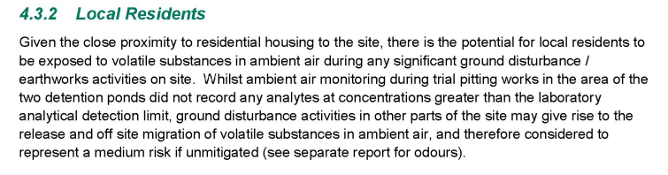
“potential….release…off site migration of volatile substances…. medium risk.”
These two detention pools are put forward as a focus to distract attention away from other parts of the site. There is currently no water feature on this site, and the creation of two is more likely to produce breakdown of drums containing pentasulphide and sequisulphide and produce hydrogen sulphide associated with their presence.
How on site workers will be protected should best be looked at at the way in which Albright and Wilson were found guilty under The Health and Safety at Work Act for their “remediation” at Portishead.
Why should local residents be put at increased admitted risk from works that are not required to protect their health,(according to ERM and Solvay)? Why should it be left to chance of one or two people making decisions at the site on any given day?
The problem with the trial pitting carried out in the areas stated is that it appears that only four samples were taken and analysed, and there is no mention as to the depth that these were taken from or how much contained any moisture. There are issues of accreditation on many tests with the laboratory used who received samples from the site 4 days after collection. The laboratory offer no insight into any of the results, and this is therefore left to ERM who cobble together their own derived conclusions.
DC_21_66208-EXTENDED_PHASE_1_HABITAT_SURVEY_2021_UPDATE_REPORT-1156465
This report states “A badger exclusion was completed under licence in July 2017 , after which the site was fenced and all excluded setts were destroyed and backfilled”
There is no mention as to the method of “exclusion”, is this a code for killing them?
This report confirms that badgers have returned to the site, with a new active sett. This gives this company a major problem concerning the works and their proposed early 2022 timescale as the ERM report states that licences to remove setts are only granted by Natural England between 1st July and November 30th. The date mentioned on the SMBC website for determination deadline is Friday 21st January 2022. The timeclock for Solvay for this application being decided is therefore ticking like an AW bomb,…..
There is a similar issue with the breeding bird season, with the chainsaw Charlies having to be active before this, if the application was approved.
DC_21_66208-BASELINE_NOISE_SURVEY_AND_CONSTRUCTION_NOISE_MODELLING-1156475
The job title “acoustic consultant” is certainly a new one on me. 😛
This is another rather pointless tick box exercise is measuring existing noises around the site, in what is a mixed use of new residential properties (which should never have been built), and industrial units. There are many technical terms in this report of which I do not profess to understand or even care about, and it is one for the nerds only.
The point of all this of course is to claim that the proposed works lasting 9 months will have limited impact on the residential occupiers, but I’m sure that the extra noise of HGV deliveries and the banging of flaps when the trucks are emptied, WILL be notable to local residents, as they were to those at Rattlechain, when they were on site doing the same thing there.
So that is it folks. You have until 17th November to object to this crap by visiting the Sandwell council planning portal and searching for DC/21/66208 . I certainly will be, and it will only need two more objections to put this bullshit under the scrutiny that it deserves without it being “delegated” to an officer of the council who knows nothing about the history of the site or its contents, and is reliant on the misinformation supplied by the applicants and their environmental consultants.