
The document below is a must read for anyone who lives next to or had their homes built on a historic landfill site. Unfortunately, what you will read in the file has probably already been deleted by the powers that be before it was published. Special thanks must go to Dan for sending me this, and it is an interesting read.
Processed-historic-landfill-sites-1
The Excel file shows information that The Environment Agency claim to hold on these blighted sites, yet it is clear that the information is very limited and in some instances I have observed , not even correct. It is the omissions however that I find most sinister, as this information is presumably used to prepare the agencies response to planning applications where they are a statutory consultee, but the information about the sites is wafer thin- most notably on the types and quantities of waste that were deposited.
The following is a rough guide to the list, and I do not profess to know what all of it means, as it appears to have been compiled esoterically to keep it that way.
The rows and cells list the waste sites; there are thousands of them in England and Wales listed.

I have no idea what “srsname” and “srs dimension” mean in cells A and B. The same nonsensical numbers are contained in columns C and D for “lower corner” and “upper corner”. Why this guff is there I do not know, but it is irrelevant to any of the sites themselves. Thus from the start, the list is largely illegible and designed to be off-putting.

Cells E and F also appear to be an unknown code, and G what appears to be an Environment Agency reference number for the site. Only at column H do we get something decipherable in the actual site name, though as can be seen, the detail to anyone not knowing where this refers to would be equally unintelligible.
![]()
Column I contains some more location detail, though most of these in the file are blank. No postcodes are contained , making it difficult to identify the site easily.

Column J is Environment Agency Waste management licence Reference? K registration number? L Waste Management catalogue reference? M bgs number- not a clue. N is the first real important clue as it reveals the name of the site licence number. Many of the West Midlands County Council SL numbers are contained here, and this has helped me find several that I was unaware of, which I am adding to my DOOMWATCH list. There are also the renumbered West Midland hazardous waste unit numbers, and the EA renumbered permits. Many however are inexplicably missing, as will be demonstrated further on in this post.
![]()
N reveals the licence holder, a company or a person, but again, may of these are blank, and the EA DO hold this basic information , yet why is it omitted here? Could it be that liability for “the polluter pays” has been removed because of cases such as those in Walsall? P gives more detail as to the licence holder’s address, though again, much of these details are blank.
![]()
Q gives the site operator name, and again the blanks are noted. R a space for more information about these.

S is the ordnance survey prefix, T the Easting reading, U the Northing reading. V is the Environment Agency regional area, for example MI appears to indicate Midlands. W is the EA area within their regional operation.
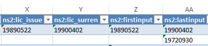
Column X is an important one as it indicates the date on which the site licence was legally issued. In the example above, this was 5th May 1989. Y indicates when the licence was legally surrendered, in the case above 4th February 1999. Column Z indicates the date when waste was first inputted into the site, and AA the last waste dumped there before licence surrender.
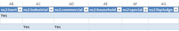
The next set of information relates to waste types that were dumped on site. This is of course the most important information, but one can see that it is largely missing, and does not give the detail needed for people to be able to find out what types of chemicals were deposited. AB stands for inert waste. B Industrial waste, C household waste, D “special waste”, and AG liquid sludge. The classification of what these categories mean has changed over time just to add more difficulty in knowing exactly what was dumped there.

AH perhaps stands for “Waste unknown” ? AH I would guess relates to gas control measures having been put in place, usually a condition of licence surrender if methane or carbon dioxide is being evolved which may take the form of a “gas vent barrier”. AJ I believe is leachate control measures, if a site is oozing out nasty liquids, as was the case with the Leigh Environmental company fiasco in Walsall. AK obviously relates to “exemption” , though I do not know what this relates to in context with site licensing. AL a licensed site? AM No licence required.
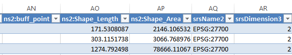
I do not know what “buff point” refers to at AN, and A0 and AP appear to give the shape in size of the site, though the units are missing, and could well have changed over time, of part of the site was transferred, as was the case at Rattlechain, before the licence was issued. AQ the same number as at the start of the list and AR another mystery.
Between AS and DM, a string of incomprehensible numbers appear, and I have no idea what these are.
EXAMPLES.
To demonstrate the abysmal gaps in this list, let’s look at two sites, the two tips as I refer to them as, Rattlechain Tip– i.e the lagoon, (Site licence SL31) and the phoney “Rattlechain Tip” SL947 , really the Duport’s tip- SL129 with a load more foundry sand crap accepted.
REAL RATTLECHAIN TIP
Real Rattlechain tip has much info missing! I would have thought that this notorious site, now known nationally as well as internationally as a the result of this website’s exposure cannot have escaped the EA’s attention- especially when the the EA as part of the now defunct CHaIRS group raised the matter of wildfowl being poisoned at several of their clandestine meetings, which I revealed through FOI requests. How can they claim to know so little? I know they hold the site licence, they supplied me with it. 🙄 A parliamentary question was asked which referenced the licence, so the civil service and Parliament are aware of the licence. So , WHO ERASED THE INFORMATION OR FAILED TO INPUT IT ONTO THIS LIST, AND FOR WHAT SINISTER PURPOSE?
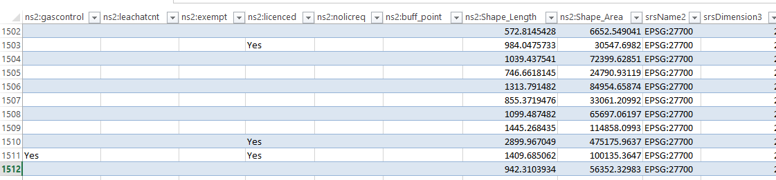
The lagoon appears at number 1512 on the list.
![]()
We get the actual correct address at column I.
![]()
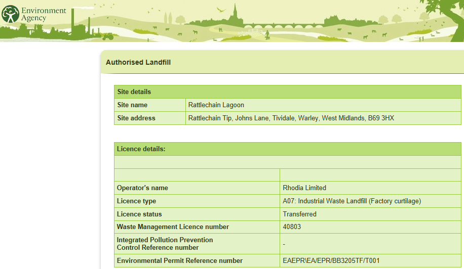
But this is I am afraid where someone hit the delete button. No more detail on the site licence detail, SL31 and the renumbered WMHWU number 644/60 and subsequent EA permit number, WML 40803 respectively.
Missing basic info, if they cannot even give the site licence number, what are they trying to hide?
They also fail to name the site operator and licence holder, of course Albright and Wilson appear to have slipped their attention, and then of course “Rhodia Limited” did too!

More blanks in the 1512 column.
They actually do manage to give the EA region and area, which of course they must know, and also the OS number.
![]()
But once again, any legitimate info about the licence, such as when it was issued is omitted. This, as the EA do know was issued on 23rd January 1978. They also know, because they supplied me with the FOI request, as to when the last input of waste was added ! The waste was special waste, industrial and also contained liquid sludge.

There appear to be some very accurate, at least in terms of what they claim to be the shape and size of the site. So how if this detail is known to them, are the key facts about the licence supposedly not?
On the former EA website What’s in your backyard, this is a screenshot I took of what it then gave as the basic facts about real rattlechain tip, though it should be pointed out, they had at this time removed the detail about what toxic waste like white phosphorus had been dumped in there, replacing this with the obscure “factory waste curtilage”- which could of course refer to anything. THUS I THINK THAT WE CAN SEE HERE, A CLEAR METHODOLOGY TO BEGIN TO ERASE THE RECORDS THAT THEY HELD, AND REPLACE THEM WITH FIRST OBSCURITY, AND THEN DELIBERATE ERASER ALTOGETHER.
FAKE RATTLECHAIN TIP
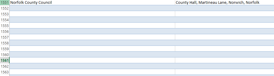
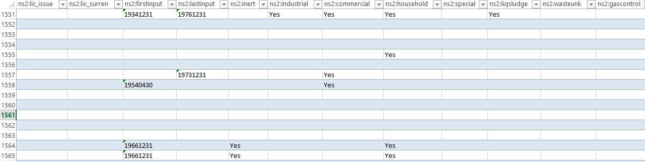
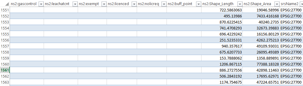
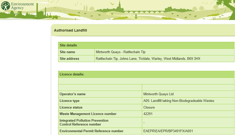
The Mintworth fiasco “rattlechain tip” is logged at 1561 on this list.
![]()
![]()
The address is given at Tipton Road Tividale.
![]()
Phoney rattlechain does not have any information as to who the site operator or address is.
The EA give details of the area once again and the OS number.

But also omitted is any detail of the site licence SL947. FROM THE INFORMATION WHICH THE EA SUPPLIED ME WITH, IE THE LICENCE IN AN FOI REQUEST, you can see that the date of issue was 23rd November 1992.
The EA therefore have this information, as well as all the modifications, as well as being able to tell me that the licence was never surrendered, only absolved with the phoney deception of “Mintworth Quays” going into voluntary liquidation- I would state for the very purpose of dodging having to surrender this licence.
The gas control measures consisted of the vent trench and the shite Christmas trees around the site perimeter, a longstanding argument between the EA and Mintworth’s consultants who thought that they knew better than the regulator, which extended the ludicrous “reclamation” scheme still further . The waste- tonnes of despoiling black foundry sand that blighted people’s windows and cars for many years, as evidenced by people’s direct objections to the length of the schemes; a “misery” which can be read HERE, as well as the crap from the sewage works development smeared into the workings on top of the Duport’s Tip foundations.
This is what the EA knew about this tip on the former What’s in my back yard website. Of course, not listed here are the considerable wastes that still remain in this Duport’s Tip, buried underneath the foundry sand, and exposed when a tatting operation for scrap metal was carried out ten years ago under the cover of heavy snow fall. Someone obviously needed some money for debts very damn quick. 😆 😆 😆
So what stunt are the Environment Agency trying to pull here? And who in this organisation are deleting information from the public realm? Do they intend to leave the Environment Agency at some point and set themselves up as “environmental consultants” where they can act as bitches for developers, having already carried out “the groundwork” of getting rid of difficult histories associated with buried hazardous wastes out of the public domain? It will obviously be put back into the public realm, by the likes of myself, and I would urge all environmental campaigners and those opposed to development in open spaces as well as health campaigners to keep a very close eye on what these dodgy civil servants are up to behind the scenes.